Buying Decision
Buying a house with subsidence: should you proceed?
Whether subsidence is a deal-breaker or a discount comes down to one distinction: active movement or historic and stable. Active subsidence can cost £15,000-£40,000 to remediate, sits on insurance records for the life of the property, and reduces resale value by 5-15% even after works. Historic movement with documentation is usually a renegotiation.
The short answer
Proceed if a structural engineer confirms the movement is historic and stable, the works are documented and warrantied, and the property remains insurable. Walk away from active progressive movement unless the seller funds full remediation before exchange. Everything else — clay geology, wide diagonal cracks, sticking doors, mature trees close to the wall — is evidence that tells you which of those two you are looking at.
Not yet at the offer stage? First see what public geology says for the postcode with the subsidence risk postcode checker.
MyPropertyScan editorialNot a surveyor
Last updated: .
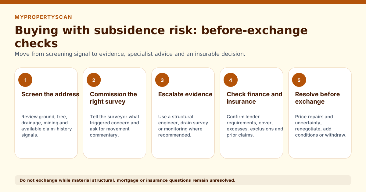
The graphic shows five buyer stages: address screening, the right survey, specialist evidence, mortgage and insurance checks, and a resolved decision before exchange.
Tool shortcut
Check a UK address before you offer, in 15 seconds
Free preview: flood risk, EPC rating, crime, tenure and air quality. The £9.99 report adds the remaining 17 checks, 22 in all, drawing on up to 15 public datasets. Subsidence, from BGS engineering geology, is in the full report.
Run a free previewWhat causes subsidence
Subsidence is downward movement of the ground supporting a building's foundations. UK subsidence has three main drivers, often in combination:
Clay soil shrink-swell
Clay soils expand when wet and contract when dry. In hot, dry summers the contraction drops foundations unevenly. London clay, Oxford clay, and Gault clay across the South and East are the highest-risk geologies. Insurance industry claims spike during dry years.
Tree root influence
Trees within their mature height of the building, on clay soil, draw water from the soil under foundations and amplify shrinkage. Oak, willow, and poplar are the worst offenders. Tree Preservation Orders complicate removal.
Drainage failure and ground washout
Leaking drains undermine foundations by washing fine soil out from under them. Often misdiagnosed as clay subsidence; a CCTV drain survey reveals it.
Reading the BGS clay evidence
The British Geological Survey publishes shrink-swell susceptibility data for the UK. More detailed lookups are available through BGS GeoIndex and commercial environmental searches. Our instant checker uses public BGS Engineering Geology at 1:1 million scale as a directional ground indicator, not parcel-level GeoSure data. To see that screening result, use our subsidence risk postcode checker, then obtain address-specific detail through GeoSure or your conveyancer's environmental search.
- 1Read the official BGS GeoSure product page at bgs.ac.uk/datasets/bgs-geosure-shrink-swell for the 1:50,000 product scope, sample maps and licensing route. Detailed GeoSure data is premium, not the source used by MyPropertyScan's instant lookup.
- 2Ask your conveyancer whether the environmental search includes licensed shrink-swell and ground-stability detail for the address.
- 3Cross-reference any mapped susceptibility with mature trees, drainage, visible movement and the seller's insurance or repair history.
The full conveyancing environmental search (Landmark, Future Climate Info) bundles BGS data with mining, contaminated land, and flood. It costs £40-£70 and is part of the standard search pack.
Signs to look for at a viewing
Most surveyors will pick these up; spotting them at the viewing lets you decide whether to commission a Level 3 survey or walk before paying for one.
| Red flag | What it suggests |
|---|---|
| Stepped diagonal cracks wider than 3mm | Especially around openings (windows, doors). Hairline cracks are usually thermal/cosmetic. |
| Doors and windows that stick or are out of square | Frames distorting suggests the building is moving. |
| Gaps between extensions and the main wall | Differential foundation depths cause separate settlement; very common on Victorian extensions. |
| Sloping or unlevel floors | Particularly in older houses; combine with crack patterns. |
| Visible cracking that continues from inside to outside through the same wall | Indicates structural rather than plaster movement. |
| Mature trees within their height of the building on clay soil | Trees draw moisture from clay; shrinkage drops the foundation underneath. |
| Ripped wallpaper around door frames or in corners | Often hides recent crack patterns sellers have papered over. |
How subsidence affects insurance and mortgage
Subsidence has the longest tail of any property defect on insurance: a single claim sits on insurance industry databases for the lifetime of the property. Three scenarios:
No history, high BGS susceptibility
Standard insurance available from mainstream insurers. Some load premiums modestly; most don't. Standard mortgage with no retention.
Historic claim, remediated, stable
Specialist insurer placement is common; mainstream insurers may quote with higher excesses (£1,000-£2,500 specifically for subsidence vs typical £100-£250). Mortgage accepts with structural engineer's report confirming stability.
Active or recent claim
Insurance is restricted to specialist insurers, often with high excesses and premium uplift. Lenders impose retentions or refuse outright until remediation is complete and warrantied.
What a subsidence survey involves
If your Level 2 or Level 3 surveyor flags movement, the standard next step is a structural engineer's assessment. Three typical paths:
- 1Visual structural engineer's report (£400-£900). Engineer inspects, classifies cracks against BRE Digest 251 categories, and gives a written opinion on cause and stability. Sufficient for many lender purposes.
- 2Level monitoring (£500-£1,500 over 6-12 months). Crack-monitor tell-tales or precision levelling installed and re-read; the gold-standard for proving movement is historic and stable.
- 3Trial pits / borehole investigation (£1,500-£5,000). Excavation near foundations to confirm depth, soil type, and any drainage issue. Required before any underpinning design.
Underpinning itself, if recommended, runs £8,000-£20,000 per affected bay; full underpinning of a typical semi can exceed £40,000.
How to negotiate if subsidence is flagged
The negotiating position depends entirely on which of the three scenarios above applies. Use the engineer's report, not the surveyor's, as the basis.
- Historic + stable, documented: 1-3% off price for cosmetic remediation; full insurance/mortgage transferability.
- Historic but undocumented, BGS high: 3-7% off, plus seller funding the engineer's report and any monitoring before exchange.
- Active or recent movement: 10-20% off plus seller-funded remediation to completion; otherwise walk away.
Always ask the seller for the last 5 years of buildings insurance claim history via the TA6 form. Insurers will see it regardless, and disclosure is required by the contract.
Frequently asked questions
Should I buy a house with subsidence?
It depends on whether the movement is active or historic. Historic, stable movement with a structural engineer's report, documented remediation and continuing insurability is normally a renegotiation rather than a deal-breaker. Active progressive movement is a reason to walk away unless the seller funds full remediation before exchange. Stepped diagonal cracks wider than 3mm, doors or windows out of square, and gaps between extensions and main walls are the signs that decide which one you are looking at.
Does subsidence affect getting a mortgage?
Active subsidence usually triggers a lender retention until a structural engineer's report and remediation plan are in place. Historic, stable movement that has been monitored is typically accepted at standard terms. If the property has been underpinned, lenders accept the property with documentation but may require specialist insurance.
How much does subsidence devalue a property?
A history of subsidence claims typically reduces market value by 5-15% even after remediation, with the lower end on properties where works are documented and warrantied, and the higher end where the cause was clay-driven and trees remain in proximity. Insurance premiums also load by 20-100% relative to the local average for the lifetime of the property's claim history.
What is clay soil shrinkage risk?
Clay soils expand when wet and shrink when dry. In dry summers the shrinkage causes foundations to drop unevenly, and trees within their mature height of the building accelerate the effect by drawing water from the soil. The British Geological Survey publishes shrink-swell susceptibility maps for the UK; London clay, Oxford clay, and Gault clay are the highest-risk geologies.
Is subsidence a reason to pull out?
Active progressive movement confirmed by a structural engineer is usually a reason to walk away unless the seller funds full remediation before exchange. Historic, stable movement with documentation and ongoing insurability is normally a renegotiation rather than a deal-breaker. The structural engineer's report is the document that decides which category the property falls into.
Keep going
Related guides
- Subsidence risk postcode checker , check the BGS clay band and local mining context for a specific postcode or city.
- Bought a house with subsidence , disclosure duties, seller and surveyor liability, and remedies once you already own it.
- UK Subsidence Risk Index , the clay belts behind most UK subsidence claims, ranked and mapped city by city.
- Noise pollution check before buying a house , another environmental check worth running alongside ground conditions.
- Air quality check before buying a house , pollution data by postcode alongside the ground-stability picture here.
- House buying checklist , the full pre-offer checklist of every property check to run.
- Bad house survey: what to do , renegotiate, pull out, or proceed when the survey flags movement.
- Subsidence monitoring on a survey , what surveyors mean by monitoring and what it commits you to.
- Flood risk when buying a house , the other major environmental risk you should check before offering.
How MyPropertyScan produces this guide, and what it is not
Published by MyPropertyScan and written by Ziad Nasr, who is accountable for its accuracy. No page here is written or reviewed by a chartered surveyor, conveyancer or regulated adviser, and we do not claim otherwise.
This page is not:
- Chartered surveying: we do not inspect properties or produce RICS Home Survey reports
- Legal advice: we do not act as conveyancers or advise on title, tenure or contracts
- Mortgage or insurance advice: we are not regulated by the FCA and give no recommendations
Figures and process steps come from the published UK datasets and standards listed on this page, not from professional practice. Pages are updated when source coverage, survey cost assumptions, or lender and legal requirements materially change. Dataset limitations are set out on the methodology page.
Spotted something out of date or wrong? Email [email protected] and we will correct it and change the update date.
Sources used
We use UK public and specialist sources where they are available. Public datasets can be incomplete, delayed, or missing for some addresses. Treat them as a starting point, not as a replacement for professional advice.
Source standard: preference goes to official government datasets, statutory bodies, professional standards, and primary dataset publishers. We cite the source family on the page and explain coverage limits rather than filling gaps with unsupported estimates.
- Check this with: Environment Agency long-term flood risk mapOfficial flood-risk service for England, including river, sea, surface water, reservoir and groundwater where available.
- Data source: HM Land Registry Price Paid DataRegistered residential sale prices for England and Wales.
- Official register: Energy Performance Certificate RegisterPublic EPC certificate lookup for an address, postcode, street or certificate number.
- Data source: British Geological Survey Engineering Geology (1:1 million)National-scale bedrock and superficial-deposit mapping used as a directional ground indicator, not parcel-level GeoSure data or a site investigation.
- Data source: Copernicus CAMS via Open-MeteoCurrent modelled PM2.5, NO₂ and European AQI from a nearby CAMS grid cell.
- Data source: DEFRA Environmental Noise Directive mappingMapped road and rail noise contour data for England, classified into MyPropertyScan's low/moderate/high bands, and separate from the CAMS air-quality source.
- Data source: Police.uk crime dataOpen street-level crime data for England, Wales and Northern Ireland.
- Check this with: Ofcom broadband checkerOfficial checker for broadband availability and speeds.
- Check this with: Ofcom mobile coverage checkerOfficial predicted mobile coverage by network.
- Data source: Food Standards Agency food hygiene ratingsPublic register used to identify nearby food and drink venues.
- Official register: Ofsted inspection reportsSchool and provider inspection report lookup for England. Fee-paying schools come from the DfE Get Information About Schools register, since around half are inspected by ISI and carry no Ofsted grade.
- Official register: Historic England National Heritage ListListed buildings, scheduled monuments and other protected heritage entries in England.