Buying Decisions
Buying a house with flood risk: offer, insurance and next steps
Flood risk changes what a sensible offer looks like, as well as what you ask the surveyor. How close the house is to a river is only the starting point: what matters is whether the property is insurable, mortgageable and priced for the risk you've found.
Around 5.5 million UK properties sit in a flood-risk area, and surface water flooding can affect homes nowhere near a river. Most buyers find out at the conveyancing stage, after they've already paid for searches and a survey. Once risk is on the table, the practical work is pricing it into your offer, sorting insurance and mortgage, and knowing when to renegotiate or walk away.
Want to check a specific address? → Is my house in a flood zone?
The short answer
Once flood risk is flagged on a property you're considering, the decision comes down to three things: whether standard buildings insurance is available at an acceptable price (Flood Re covers most homes built before 2009), whether the mortgage lender is satisfied once the environmental search and an insurance quote are in, and whether the price already reflects the risk you've found. Confirm the exact address first, then work through insurance, mortgage and negotiation before you commit.
MyPropertyScan editorialNot a surveyor
Last updated: .
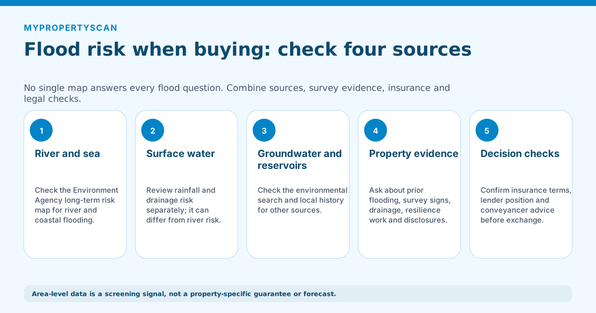
The five-stage flow checks river and coastal risk, surface-water risk, groundwater and reservoir sources, property-specific evidence, then insurance, lending and conveyancing before exchange.
Tool shortcut
Check flood signals for a UK address in 15 seconds
Flood-zone signals where available, with the manual follow-up checks spelled out.
Run a free previewGet the address-level evidence first
Everything in this guide assumes you already have an address-level result, not a general sense that the area “floods sometimes.” Use the free flood zone lookup for the exact property, reading rivers and sea, surface water, groundwater and reservoirs as separate layers, since a property can be nowhere near a river and still carry significant surface-water risk.
Save the report the map generates and send it to your conveyancer alongside the seller's TA6 form, which asks directly whether the property has flooded before. The two need reading together: a low-risk map result alongside a disclosed flood event is a very different picture from a low-risk result and a clean TA6.
What the EA flood risk zones mean
The EA bands flood risk from rivers and the sea into four categories. The annual chance number is what matters for insurance, not the label.
| Band | Annual chance | What it means for buyers |
|---|---|---|
| Very Low | <0.1% annual chance of flooding from rivers or sea | Standard insurance, no restrictions, no buyer concern. |
| Low | 0.1% – 1% annual chance | Insurance standard. Worth checking surface water separately. |
| Medium | 1% – 3.3% annual chance | Some insurers load the premium. Flood Re eligibility important on pre-2009 stock. |
| High | >3.3% annual chance (1 in 30 years or more frequent) | Specialist insurer placement common. Lender appetite varies. Pre-offer due diligence essential. |
Planning policy uses a parallel set of Flood Zones 1-3a-3b: Zone 1 is below 0.1% annual chance, Zone 2 is 0.1-1%, Zone 3a is 1%+ from rivers, Zone 3b is the functional floodplain. Conveyancers often refer to these zones; buyers should ask for both the EA risk band and the planning Flood Zone.
Surface water vs river flooding
Two different risks, mapped separately, often confused. Surface water (pluvial) flooding happens when heavy rainfall overwhelms drains or runs off hard surfaces. River (fluvial) flooding happens when a river breaches its banks or defences.
Why surface water matters more for many buyers: a house can sit nowhere near a river but still flood from surface water during a summer storm. The 2007 floods and the 2024 winter storms both caused most of their damage from surface water, not rivers. Sellers often disclose "not in a flood zone" truthfully on the river map while surface water risk is medium or high.
Coastal and estuary cities need the same double check: river or sea flooding plus surface-water layers. The Southampton tidal flood risk guide shows how that works around Southampton Water, the Test and the Itchen. For national city-level context, compare places in the UK Property Flood Risk Index.
Always check both. The EA map presents them as separate layers, so toggle them independently.
How flood risk affects your mortgage
Mortgage lenders rarely refuse outright on flood risk alone. What they care about is whether buildings insurance is available at standard cost. The chain usually runs:
- Conveyancer's environmental search flags flood risk to the solicitor
- Solicitor reports to lender, asks buyer to confirm insurance can be obtained
- Buyer obtains a quote, shares the policy with the lender
- Lender confirms drawdown if insurance is in place at acceptable cost
If insurance is only available at multiples of standard market rates, or with very high excesses, some lenders impose retentions or refuse. Specialist lenders (rather than mainstream high-street banks) are sometimes more comfortable with high flood risk.
How flood risk affects your insurance
Three scenarios run the market for flood-affected homes:
Flood Re-eligible (most pre-2009 homes)
Flood Re is a UK reinsurance scheme that caps the flood element of premiums for most homes built before 1 January 2009. Insurers cede the flood risk to Flood Re and offer near-standard premiums. The scheme is set to end in 2039.
Post-2009 build, high flood risk
Not Flood Re-eligible. Specialist insurers will quote, often at materially higher premiums and excesses. Some new-builds in flood-risk areas have struggled to find cover at all; planning policy now requires flood resilience measures for new builds in high-risk areas.
Property with prior flood claim history
The seller's claim history follows the property in insurer databases. Ask for the last 5 years of claims via the TA6 form; insurers will quote based on what they find regardless of disclosure.
Buying a house that has flooded before
A previous flood doesn't automatically mean walk away: many flooded homes are bought, insured, and lived in without issue once the right checks are done. A property that has flooded once can be a reasonable buy; one that floods repeatedly rarely is. Work through five things before you commit:
- 1Claim history. The seller's TA6 form must disclose past flooding, but insurer databases hold the last 5+ years of claims regardless. Ask for dates, depth, and cause of every event.
- 2What was done since. Flood resilience and resistance works (door barriers, non-return valves, raised electrics, pumped sumps, sealed floors) materially change the risk. Get documentation and guarantees.
- 3Insurance, in writing, before exchange. Get a real quote on the actual address, not a postcode estimate. Most pre-2009 homes remain Flood Re-eligible even after a claim; check the premium and excess you'd actually pay.
- 4Commission a regulated flood search. Beyond the free EA map, a paid flood search assesses river, surface water, groundwater, and coastal risk for the address and is what your lender and conveyancer rely on.
- 5Resale. A disclosed flood history follows the property. Factor in that your future buyer will run the same checks you are running now.
The paid search usually comes bundled in your conveyancer's pack; see the environmental search and water and drainage search guides for what each one reports and when to order it.
How to negotiate if flood risk is high
Flood risk negotiation is harder than survey-based negotiation because the seller often argues (correctly) that the risk doesn't change the building. The leverage is in the cost differential.
- 1Get two specialist insurance quotes; compare to the standard market rate for the area.
- 2Calculate the 25-year premium differential and present it as the basis for a price reduction.
- 3If flood resilience works (door barriers, non-return valves, raised electrics) are missing, get a quote (£1,500-£10,000) and ask the seller to fund or deduct.
- 4For Flood Zone 3 properties, expect 5-15% off the agreed price as a typical settled outcome where the seller is motivated.
When to walk away
Three clear pull-out triggers:
- Standard insurance is unavailable and specialist quotes exceed acceptable cost (typically £2,000+/year for a normal-value home)
- The property has had two or more flood claims in the last 10 years and resilience works haven't been done
- The lender refuses outright after seeing the EA report, and switching lender produces the same answer
Frequently asked questions
What should I confirm before making an offer on a flood-risk property?
Confirm the exact address on the official flood map before you offer: the Environment Agency long-term flood-risk service in England, Natural Resources Wales in Wales, or SEPA in Scotland. Read river and sea, surface water, reservoir and groundwater layers separately, then get a real buildings-insurance quote for the address before you commit to exchange.
Should I buy a house in a flood risk area?
Buying in a flood risk area can be reasonable if standard buildings insurance is available at an acceptable cost, the property has resilience measures where needed, and the resale impact is priced in. Walk away when insurance is unavailable or unaffordable, the home has repeated flood claims, or the lender refuses.
Does flood risk affect getting a mortgage?
Mortgage lenders rarely refuse solely because a property has flood risk. They mainly want evidence that buildings insurance is available at a standard or acceptable cost. The conveyancer reports the environmental search to the lender, the buyer obtains an insurance quote, and the lender confirms drawdown if cover is suitable.
What is Flood Re and does it apply to the property I'm buying?
Flood Re is a UK government-backed reinsurance scheme for most homes built before 1 January 2009. It caps the flood element of buildings insurance, allowing insurers to offer near-standard premiums on higher-risk properties. Post-2009 homes are not eligible, and the scheme is currently due to end in 2039.
What is the difference between river flooding and surface water flooding?
River flooding happens when a river breaches its banks or defences. Surface water flooding happens when heavy rain overwhelms drains or runs off hard surfaces faster than the ground can absorb it. Surface water can affect houses nowhere near a river, so buyers should check both layers separately.
Keep going
Related guides
- Is my house in a flood zone? , the lookup itself, plus what a zone means once you already own the property.
- House buying checklist , the full pre-offer checklist of every property check to run.
- Bad house survey: what to do , renegotiate, pull out, or proceed when the survey comes back bad.
- Drainage issues on a survey , how surveyors flag drainage and what it means for flood vulnerability.
- Subsidence risk when buying a house , the other major environmental risk you should check before offering.
- Noise pollution check before buying a house , road and rail noise by postcode.
- Air quality check before buying a house , pollution data by postcode before you offer.
How MyPropertyScan produces this guide, and what it is not
Published by MyPropertyScan and written by Ziad Nasr, who is accountable for its accuracy. No page here is written or reviewed by a chartered surveyor, conveyancer or regulated adviser, and we do not claim otherwise.
This page is not:
- Chartered surveying: we do not inspect properties or produce RICS Home Survey reports
- Legal advice: we do not act as conveyancers or advise on title, tenure or contracts
- Mortgage or insurance advice: we are not regulated by the FCA and give no recommendations
Figures and process steps come from the published UK datasets and standards listed on this page, not from professional practice. Pages are updated when source coverage, survey cost assumptions, or lender and legal requirements materially change. Dataset limitations are set out on the methodology page.
Spotted something out of date or wrong? Email [email protected] and we will correct it and change the update date.
Sources used
We use UK public and specialist sources where they are available. Public datasets can be incomplete, delayed, or missing for some addresses. Treat them as a starting point, not as a replacement for professional advice.
Source standard: preference goes to official government datasets, statutory bodies, professional standards, and primary dataset publishers. We cite the source family on the page and explain coverage limits rather than filling gaps with unsupported estimates.
- Check this with: Environment Agency long-term flood risk mapOfficial flood-risk service for England, including river, sea, surface water, reservoir and groundwater where available.
- Data source: HM Land Registry Price Paid DataRegistered residential sale prices for England and Wales.
- Official register: Energy Performance Certificate RegisterPublic EPC certificate lookup for an address, postcode, street or certificate number.
- Data source: British Geological Survey Engineering Geology (1:1 million)National-scale bedrock and superficial-deposit mapping used as a directional ground indicator, not parcel-level GeoSure data or a site investigation.
- Data source: Copernicus CAMS via Open-MeteoCurrent modelled PM2.5, NO₂ and European AQI from a nearby CAMS grid cell.
- Data source: DEFRA Environmental Noise Directive mappingMapped road and rail noise contour data for England, classified into MyPropertyScan's low/moderate/high bands, and separate from the CAMS air-quality source.
- Data source: Police.uk crime dataOpen street-level crime data for England, Wales and Northern Ireland.
- Check this with: Ofcom broadband checkerOfficial checker for broadband availability and speeds.
- Check this with: Ofcom mobile coverage checkerOfficial predicted mobile coverage by network.
- Data source: Food Standards Agency food hygiene ratingsPublic register used to identify nearby food and drink venues.
- Official register: Ofsted inspection reportsSchool and provider inspection report lookup for England. Fee-paying schools come from the DfE Get Information About Schools register, since around half are inspected by ISI and carry no Ofsted grade.
- Official register: Historic England National Heritage ListListed buildings, scheduled monuments and other protected heritage entries in England.